Newfound Lake, New Hampshire!
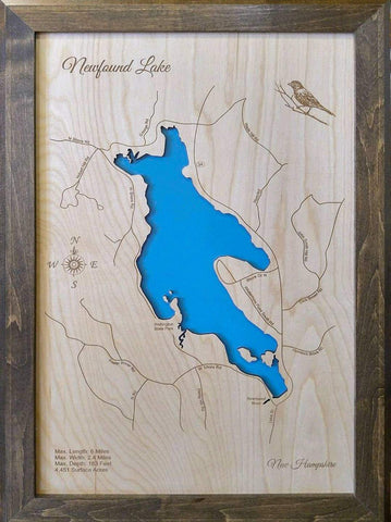
This is our beautifully detailed, laser engraved and precision cut Map of Newfound Lake in Grafton County, New Hampshire with the following interesting stats carved into it:Maximum Length: 6 Miles
Maximum Width: 2.4 Miles
Maximum Depth: 183 Feet
Surface Area: 4,451 Acres
The lake was originally fought over by John Mason and Peter Wheelright, who both claimed they owned a large plot of land with the lake being inside that plot.
On November 7, 1629, Mason, a merchant from London, had the land from Newfound Lake to the
Merrimack River in Massachusetts granted to him.
Six months earlier, Reverend Peter Wheelright bought a large plot of land from native Indians that was similar to the land John Mason received.
The argument went to court and lasted for more than one hundred years.
Eventually, Mason's sixth heir, John Tufton Mason, won the case and sold the land to a syndicate known as the Masonian proprietors.
On September 14, 1753, a syndicate living in Chester, New Hampshire, bought the land from the Mason proprietors and the land became known as New Chester.
On February 12, 1788, the territory was divided up, and the territory north and east of Newfound Lake and the Newfound River was incorporated as Bridgewater.
Two thirds of the lake was incorporated as Bristol on June 24, 1819.
#newfoundlake
#graftoncounty
#newhampshire
#newhampshirelakewoodmap
#merrimackriver
#massachusetts
#bridgewater
#personalhandcrafteddisplays
#doctorsofdisplays
#phds4u
🌅🛶