
Skip to product information


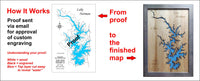
**Please note: Actual layout may vary based on size. If you'd like to see a proof of the layout prior to production, let us know,


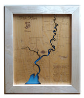
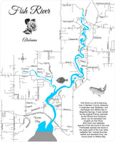
This is a beautiful, detailed, laser engraved and precision cut map, including lake information such as surface area, elevation and maximum depth.
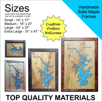
Included With All Maps:
- Points of interest laser engraved into the map face
- A blue, self-adhesive Swarovski crystal to mark your preferred location on the map
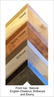
Our maps are made from beautiful birch plywood. Natural variances in the wood grain ensure a unique work of art. Once the map is cut, it is hand sanded multiple times, mounted on a blue board to highlight the water, and given a clear coat for a lustrous wood shine. Proudly made in the USA by American workers in an American owned business.
**Please note: Actual layout may vary based on size. If you'd like to see a proof of the layout prior to production, let us know,
Custom Engraving Available
Add up to 2 lines of custom engraving at no additional cost!
Standard Engraving:
- Fish River is a 28.9-mile-long river in Baldwin County, Alabama. It originates near Stapleton, and discharges into Weeks Bay in Magnolia Springs. It was named by the original French colonists as the Riviere Aux Poissons, which can be translated into English as Fish River.
- Both fresh and saltwater species of fish are found in the river. Freshwater species are found in the upper parts of the river while saltwater fish, namely flounder, redfish and speckled trout, are found closer to Weeks Bay.