
Skip to product information

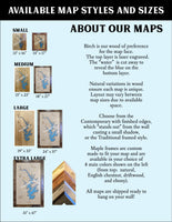
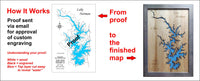
**Please note: Actual layout may vary based on size. If you'd like to see a proof of the layout prior to production, let us know,


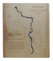
This is a beautiful, detailed, laser engraved and precision cut map, including lake information such as surface area, elevation and maximum depth.
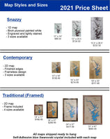
Included With All Maps:
- Points of interest laser engraved into the map face
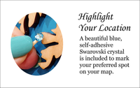
- A blue, self-adhesive Swarovski crystal to mark your preferred location on the map
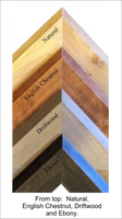
Our maps are made from beautiful birch plywood. Natural variances in the wood grain ensure a unique work of art. Once the map is cut, it is hand sanded multiple times, mounted on a blue board to highlight the water, and given a clear coat for a lustrous wood shine. Proudly made in the USA by American workers in an American owned business.
**Please note: Actual layout may vary based on size. If you'd like to see a proof of the layout prior to production, let us know,
Custom Engraving Available
Add up to 2 lines of custom engraving at no additional cost!
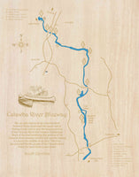
The 30-mile stretch of the Catawba River between Wylie Hydro and the upper end of Fishing Creek Lake is now the longest portion of the Catawba River that remains undammed.
Much of the land bordering this portion of the Catawba River remains wooded and natural making it a haven for wildlife of all sorts.
The river has provided for the people of the Catawba River Valley for more than 12,000 years.