
Skip to product information


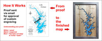
**Please note: Actual layout may vary based on size. If you'd like to see a proof of the layout prior to production, let us know,


This is a beautiful, detailed, laser engraved and precision cut map, including lake information such as surface area, elevation and maximum depth.
Included With All Maps:
- Points of interest laser engraved into the map face
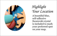
- A blue, self-adhesive Swarovski crystal to mark your preferred location on the map
Our maps are made from beautiful birch plywood. Natural variances in the wood grain ensure a unique work of art. Once the map is cut, it is hand sanded multiple times, mounted on a blue board to highlight the water, and given a clear coat for a lustrous wood shine. Proudly made in the USA by American workers in an American owned business.
**Please note: Actual layout may vary based on size. If you'd like to see a proof of the layout prior to production, let us know,
Custom Engraving Available
Add up to 2 lines of custom engraving at no additional cost!
Standard Engraving:
- Fish: White bass, Northern pike, Walleye, Largemouth bass, Smallmouth bass
- Area: 26 Square Miles
- Surface Elevation: 883 Feet
- Shoreline: 60 Miles
- Maximum Depth: 30 Feet
It connects to Petenwell Lake. It covers 16,640 acres and reaches thirty feet deep. Construction of the Castle Rock Dam was started in 1947 and completed four years later.