
Skip to product information


**Please note: Actual layout may vary based on size. If you'd like to see a proof of the layout prior to production, let us know,


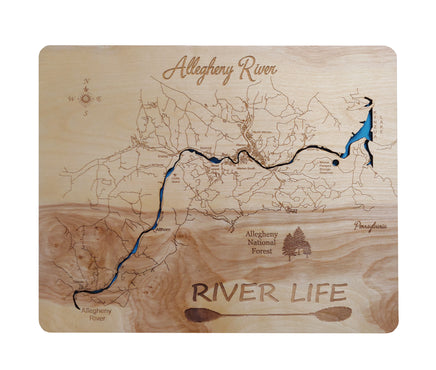
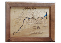
This is a beautiful, detailed, laser engraved and precision cut map, including lake information such as surface area, elevation and maximum depth.
Included With All Maps:
- Points of interest laser engraved into the map face
- A blue, self-adhesive Swarovski crystal to mark your preferred location on the map
Our maps are made from beautiful birch plywood. Natural variances in the wood grain ensure a unique work of art. Once the map is cut, it is hand sanded multiple times, mounted on a blue board to highlight the water, and given a clear coat for a lustrous wood shine. Proudly made in the USA by American workers in an American owned business.
**Please note: Actual layout may vary based on size. If you'd like to see a proof of the layout prior to production, let us know,
Custom Engraving Available
Add up to 2 lines of custom engraving at no additional cost!
- The Allegheny River is a principal tributary of the Ohio River. The river rises in Pennsylvania and flows north into New York, and south into Pennsylvania again joining with the Monongahela River in the middle of Pittsburgh. Pittsburgh developed at this confluence. The Allegheny and the Monongahela confluence is the beginning of the Ohio River. The river is approximately 321 miles long with over 100 islands between Kinzua Dam and Oil City with significant ecological, scenic and recreational features. Seven of these islands, totaling 368 acres, comprise the Allegheny Islands Wilderness, the smallest federally-designated Wilderness in the United States.