
Skip to product information


**Please note: Actual layout may vary based on size. If you'd like to see a proof of the layout prior to production, let us know,


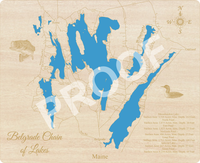
This is a beautiful, detailed, laser engraved and precision cut map, including lake information such as surface area, elevation and maximum depth.
Included With All Maps:
- Points of interest laser engraved into the map face
- A blue, self-adhesive Swarovski crystal to mark your preferred location on the map
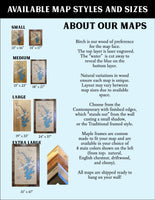
Our maps are made from beautiful birch plywood. Natural variances in the wood grain ensure a unique work of art. Once the map is cut, it is hand sanded multiple times, mounted on a blue board to highlight the water, and given a clear coat for a lustrous wood shine. Proudly made in the USA by American workers in an American owned business.
**Please note: Actual layout may vary based on size. If you'd like to see a proof of the layout prior to production, let us know,
Custom Engraving Available
Add up to 2 lines of custom engraving at no additional cost!
- Messalonskee Lake- Surface Area: 3,510 Acres, Max. Depth: 113 Feet
- North Pond – Surface Area: 2,873 Acres, Max. Depth: 20 Feet
- East Pond– Surface Area: 1,823 Acres, Max. Depth: 27 Feet
- McGrath Pond – Surface Area: 486 Acres, Max. Depth: 27 Feet
- Long Pond – Surface Area: 2,714 Acres, Max. Depth: 106 Feet
- Salmon Lake – Surface Area: 667 Acres, Max. Depth: 57 Feet
- Great Pond – Surface Area: 8,239 Acres, Max. Depth: 69 Feet
East Pond empties into North Pond, which is connected to Great Pond. Great Pond empties into Long Pond, which flows into Messalonskee Lake. McGrath Pond flows into Salmon Lake, which is also coupled with Great Pond. Together, these lakes make up a combined surface area of 20,311 acres.