
Skip to product information

**Please note: Actual layout may vary based on size. If you'd like to see a proof of the layout prior to production, let us know,


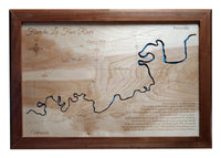
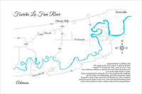
This is a beautiful, detailed, laser engraved and precision cut map, including lake information such as surface area, elevation and maximum depth.
Included With All Maps:
- Points of interest laser engraved into the map face
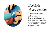
- A blue, self-adhesive Swarovski crystal to mark your preferred location on the map
Our maps are made from beautiful birch plywood. Natural variances in the wood grain ensure a unique work of art. Once the map is cut, it is hand sanded multiple times, mounted on a blue board to highlight the water, and given a clear coat for a lustrous wood shine. Proudly made in the USA by American workers in an American owned business.
**Please note: Actual layout may vary based on size. If you'd like to see a proof of the layout prior to production, let us know,
Custom Engraving Available
Add up to 2 lines of custom engraving at no additional cost!
Standard Engraving:
- Approximately 151 Miles Long
The origin of the river’s name is open to debate; “fourche” is French for “fork,” and “La Fave” may be in reference either to a family that once lived along the river or to early settler Peter La Fave.
Early transportation along the river was conducted by keelboat, but even this was challenging, given the numerous shoals along the course of the waterway. On March 3, 1879, Congress passed an act to improve the river. This included dynamiting some of the rocky shoals to create a deeper channel for transportation.